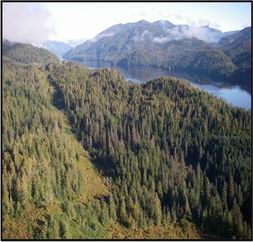
Ketchikan - Shelter Cove Road

NEW: December 2014 Project Update - Road Alignment Selected and Application for U.S. Corp of Engineers Permit Submitted
Project No. 68405
The proposed project would extend the Ketchikan Road system from Revilla Road to the Shelter Cove road system on Carroll Inlet. DOT&PF has obtained right-of-way (ROW) easements for the White River Road on Forest Service (FS) lands, the White River Road on Cape Fox lands, and the White River Road on Mental Health Trust Lands. A new road would be constructed from the end of White River Road along the coast from Leask Cove to Bat Cove and north along Salt Lagoon and Salt Creek to the existing Shelter Cove Road. Shelter Cove Road is currently a public road maintained by the FS, and DOT&PF may obtain ROW easement for this road in the future.
Project Background
The Department of Transportation and Public Facilities (DOT&PF) began a preliminary reconnaissance study in the spring of 2007 that examined the proposal to expand road access in the Ketchikan area between Shelter Cove on Carroll Inlet and Lake Harriet Hunt. In November 2008, statewide Alaska voters approved a Transportation General Obligation (GO) Bond that included $10 million for the construction of a 14‘ single lane rock and gravel road between Lake Harriet Hunt and Shelter Cove, connecting these two road systems on Revilla Island. A Reconnaissance Report considered four main alternative routes and recommended proceeding with the “Low-Low” route. DOT&PF has now obtained ROW obtained for existing roads between Revilla Road and Leask Cove. Preliminary design has been completed for a section of new road between Leask Cove and Shelter Cove Road, and the environmental review of the proposed alignment is now under way.
Project Purpose and Need
The proposed project’s purposeis to provide a public surface transportation link that would extend the existing Ketchikan road system to the Shelter Cove road system. This would have the benefit of increasing the public’s opportunities for recreation, subsistence hunting and gathering, tourism, and economic development consistent with the public land use plans and policies. Road access to public lands is limited in the Ketchikan area. The results of a household survey conducted in Ketchikan during project reconnaissance identified an unmet need for access to recreational and subsistence-related activities in the lands surrounding the proposed Shelter Cove road. In the 2004 Southeast Alaska Transportation Plan (SATP), DOT&PF identified a possible link between Southeast Alaska and the Canadian highway system at the Cassiar Highway. That proposed link included a Revillagigedo Highway, a portion of which is between Lake Harriet Hunt and Shelter Cove. That plan is being updated, but the 2004 version is still the approved transportation plan for Southeast Alaska.
Project Status
Public meetings were held in the Ketchikan Gateway Borough Assembly Chambers September 7, 2011 and on March 6, 2012 to discuss highlights of the Draft Reconnaissance Report. After receiving and analyzing agency and public comments, DOT&PF recommended Alternative II, the “Low-Low” Alternative in the Final Reconnaissance Report. The Department began preliminary design for the recommended alignment and has started the environmental review for the project. An application for a U.S. Army Corps of Engineers (USACE) permit was submitted and a Public Notice for the application is available at http://www.poa.usace.army.mil/Missions/Regulatory/PublicNotices.aspx.
Links to additional documents are available here.
