
Richardson Highway / Steese Expressway
Corridor Study Project Project No. 60799
Frequently Asked Questions
Q: What's a PEL study?
A: PEL stands for "Planning and Environmental Linkage." PEL studies are one of the Federal Highway Administration's (FHWA) Every Day Counts program initiatives
designed to speed project delivery. The study is essentially a planning document for the corridor, with the goal of developing project concepts with community and public input.
This study differs from past studies because of the environmental linkage component. Preliminary environmental impacts will be identified for each concept, and through public,
local government, and agency cooperation, overall concepts which do not satisfy the study's purpose and need will be eliminated.
Through the PEL study, ADOT&PF can identify "red flags" early and make better informed decisions on which projects go forward and which shouldn't.
See FHWA's website for additional information regarding PEL: http://www.environment.fhwa.dot.gov/integ/edc.asp

Q: When will concepts developed from this study be constructed?
A: The final overall corridor concept selected will be broken into smaller project improvements than can be constructed in a phased approach. Reconstructing the entire corridor at one
time would be very difficult due to construction impacts on traffic and funding availability. As such, some improvements may be constructed within the next few years while others may
not be constructed for up to 20 years. After selection of the final corridor concept, recommendations for project priorities will be developed for the smaller project improvements.
Q: What area does the study cover?
A: The project begins at the Badger Road interchange on the Richardson Highway and ends at the Chena Hot Springs Road interchange on the Steese Expressway including some adjacent streets.
Q: When will the study be complete?
A: The final PEL study will be complete in mid-2015. The Public Review Draft can be
found here
![]() 30mb.
30mb.
Q: What sorts of concepts for the corridor were developed?
A: We're looked at the corridor as a whole and developed three overall concepts.
- The first corridor concept is the preferred concept, and emphasizes mobility. It converts major at-grade intersections in the corridor to grade-separated interchanges.
- The second corridor concept attempts to balance mobility with access. It’s a blend of at-grade intersection improvements and grade-separated interchanges.
- The third corridor concept emphasizes access. It maintains and improves the existing at-grade intersections in the corridor. Improvements may include additional lanes, turn pockets, and frontage roads.
Q: What does "mobility" mean as it relates to the corridor concepts?
A: Mobility emphasizes reducing travel time through the corridor.
Q: What does "access" mean as it relates to the corridor concepts?
A: Access emphasizes providing direct connection to adjacent properties along the corridor.
Q: What's an at-grade intersection?
A: The general area where two or more roads join or cross. Common traffic controls for at-grade intersections include traffic signals, stop signs, or yield signs. Intersections may
have 3 or more legs. The most common intersection type has four legs.

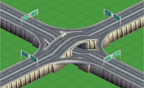
Q: What's a grade-separated interchange?
A: A system of interconnecting two or more roads on different levels. There are multiple configurations to design an interchange, but some of the more popular types include:
trumpet, diamond, cloverleaf, single-point urban interchange (SPUI), and many others. Other common names for interchange include overpass, underpass, and flyover.
Q: Has ADOT&PF coordinated with other stakeholders on this study?
A: Yes. See our Public Involvement Page for more information regarding our coordination efforts.
Q: How can I learn more or keep informed about this project?
A: Check this website for updates as new information is posted, subscribe to our email list, or email our project manager.
Project Information
PLEASE NOTE: Adobe Acrobat PDF files require a free viewer available directly from Adobe.