
Frequently Asked Questions

What is the Seward to Glenn Connection PEL Study?
The Alaska Department of Transportation and Public Facilities (DOT&PF), Central Region, is conducting a Planning and Environmental Linkages (PEL) Study to consider potential transportation improvements in Anchorage, with the intent to improve:
- Safety
- Livability
- Regional travel between the Seward and Glenn Highways
- Local travel within the surrounding neighborhoods
- Freight connection between the Port and the Seward and Glenn Highways
The PEL Study process gives DOT&PF an opportunity to engage the community and stakeholders in identifying transportation and community needs, developing potential solutions, and narrowing down the list of alternatives that will be carried into future environmental review and design processes.
Who is conducting the study?
DOT&PF is managing the study in cooperation with Anchorage Metropolitan Area Transportation Solutions (AMATS). AMATS is the Metropolitan Planning Organization responsible for transportation planning for the Anchorage Bowl and Chugiak-Eagle River areas. Funding for the study is from the Federal Highway Administration, through AMATS.
What are the limits of the study area?
The study boundary generally follows Bragaw Street on the east, Northern Lights on the south, C Street on the west, and Joint Base Elmendorf-Richardson on the north. It includes areas where potential transportation improvements could be developed between the Glenn and Seward Highways and to and from the Port of Alaska. The study area is broad enough also to gauge how nearby community councils and traffic levels on parallel routes may be affected.
Figure 1: General Study Area

What is a Planning and Environmental Linkages (PEL) Study?
According to the Federal Highway Administration (FHWA), a PEL Study represents a collaborative and integrated approach to transportation decision-making that (1) considers environmental, community, and economic goals early in the transportation planning process and (2) uses the information, analysis, and products developed during planning to inform the environmental review process. See more at Planning and Environment Linkages | Environmental Initiatives | Environmental Review Toolkit | FHWA (dot.gov). Learn more about the PEL Study process in this downloadable handout.
What are the potential benefits of a PEL Study?
The PEL process aids the transportation decision-making process. The PEL Study will:
- Identify potential benefits and impacts to communities, the environment, and the economy early in the planning stage, making the project more efficient and cost-effective.
- Engage partner agencies, stakeholders, and the public, building project awareness and support through transparent and consistent communication.
- Provide opportunities early and often for the public to provide input that shapes the project.
- Narrow down the range of project alternatives to carry into future environmental review, design work, and construction project steps.
What is the PEL Study schedule?
The PEL Study process began in June 2021 and is expected to be completed in 2025 (see Figure 2). Dates are subject to change.
Once the final PEL Study is complete, the project may move into additional environmental review and design through the National Environmental Policy Act (NEPA) process. Funding for construction projects would need to be included in the Alaska Statewide Transportation Improvement Program (STIP) and AMATS Transportation Improvement Plan (TIP) if the projects identified in the PEL are to advance to NEPA, design, right-of-way acquisition (i.e., purchasing private property if needed), and construction.
Figure 2: Project Schedule

What is the study’s background?
Connecting the Seward Highway to the Glenn Highway was discussed as early as 1972 in the Anchorage Long Range Transportation Plan (LRTP).
In 2001, AMATS conducted the East Anchorage Study of Transportation. It was determined that connecting the Seward and Glenn Highways was important to solving traffic congestion in the Anchorage Bowl.
In 2005, the “Highway to Highway” (H2H) project was adopted as part of the Anchorage Bowl 2025 LRTP. DOT&PF started an Environmental Impact Statement (EIS) process for the H2H project, but the EIS was canceled in 2010 by the Governor.
In 2020, DOT&PF, in partnership with community organizations (i.e., Fairview Community Council), recognized the continuing need to address transportation issues in this corridor. DOT&PF then included the PEL Study as part of the AMATS Metropolitan Transportation Plan (MTP) 2040.
What prompted the PEL study?
The existing connection between the Seward and Glenn Highways on the Ingra-Gambell couplet through Fairview causes major safety and livability issues in a predominantly ethnic and lower income neighborhood. It is also notable that Fairview has a much higher percentage of residents without vehicles than most neighborhoods in Anchorage, making it more challenging for those users to cross roughly 40,000 vehicles per day on the Glenn Highway to access basic services, such as groceries, the post office, churches, schools, parks, employment, etc. For these reasons, the Fairview Community Council requested AMATS provide funding to complete a freeway connection study.
When the PEL Study began, it was identified in the previously adopted Anchorage Metropolitan Transportation Plan (MTP), 2040. That plan indicated that the study should “define a vision for the future of this connection, identify environmental and resource concerns and opportunities in the study area, and use the information to develop reasonable alternatives through consultation with the affected agencies and the public.” This PEL Study is officially titled the Seward Highway to Glenn Highway Planning and Environmental Linkages Study (IRIS Program No. CFHWY00550 | Federal Project No. 0001653).
What is different about this study?
DOT&PF is conducting this PEL Study as a re-examination of a long-standing project in the Anchorage MTP 2040 that called for connecting the Seward Highway and the Glenn Highway through Anchorage and included a project (MTP #214) with the following description: “Construct freeway connection between Seward Highway/20th Avenue and 13th Avenue with freeway access and egress ramps onto Ingra/Gambell Streets near the northern termini of the project. Reconstruct Ingra Street/Gambell Street and construct separated grade crossings of the freeway to reconnect portions of the east-west street system. Construct an interchange at Airport Heights Drive and Glenn Highway Intersection.” The Seward to Glenn Connection PEL Study is going beyond a strict examination of a “freeway connection” and is considering a broad scope of ideas, including:
- Re-examining anticipated traffic levels to determine if a “freeway” is still the right facility type. In fact, data along with public feedback has led the project team to move away from a freeway solution. The roadway connections have been revised to include reduced lanes and slower speeds, with the continued intent to remove regional and port traffic from neighborhood streets.
- Identifying potential access improvements to and from the Port of Alaska.
- Considering community and neighborhood viewpoints in identifying problems and potential solutions.
- Advancing the PEL Study by taking a fresh look at the transportation needs and community goals, objectives, and visions in plans adopted since the last time this project was studied.
What has changed in the area since highway mobility needs and alternatives were last studied in detail?
When the project area was last studied in detail, the Knik Arm Crossing project and a viaduct (long bridge) roadway over the ship creek industrial area connecting Gambell/Ingra to the Port of Alaska were still part of the adopted Municipal Transportation Plan. Since then, economic conditions have been vastly different, and growth and land use development patterns are now subject to a newly adopted land use plan map. For these reasons, traffic patterns and congestion levels are different from those studied in 2010. It is important to re-examine the transportation needs in light of these and other changes to make certain the improvements address the existing needs.
What problems will the study examine?
The study is intended to address the following on the Seward to Glenn Highways:
- Safety (most notably for non-motorized users)
- Livability
- Regional travel between the Seward and Glenn Highways (interstate highway system)
- Local travel within the surrounding neighborhoods
- Access between the interstate highway system and the Port of Alaska
To improve livability and local travel within the surrounding neighborhoods, the project team has as follows:
- Established effective communications management protocols for a solid project foundation, identified problems to be solved based on updated data and public input,
- Developed a Purpose and Need Statement and evaluation criteria based on issues identified through data analysis and public/stakeholder outreach
- Developed alternative concepts and reviewed them for fundamental flaws and practicality
- Refined and further developed reasonable alternatives to reduce neighborhood and environmental resource impacts resulting from vehicle noise, residential and business relocations, cut-through traffic, and congestion
Based on feedback on the refined alternatives and additional data gathering, the team will arrive at a recommended alternative(s) for various roadway and active transportation improvement projects in the study area.
Developed alternatives will address identified problems based on engineering and environmental analyses. As a PEL Study, the efforts will integrate community and environmental factors into the decision-making process, with a strong emphasis on public involvement.
How will the study be used?
Once the final PEL Study is complete, multiple projects (or components of the overall plan) may move forward for additional environmental review and engineering design through the NEPA process. The results of the study may also feed into a subsequent update of the MTP 2050, potentially updating needed improvements, cost estimates, and the timing and phasing of improvements. Funding for construction projects would need to be included in the STIP and TIP if the projects identified through the PEL are to advance to NEPA, design, right-of-way acquisition (i.e., purchasing private property, if needed), and construction.
How will the project team engage stakeholders and the public in the PEL process?
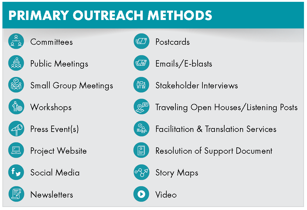
The PEL Study process includes robust opportunities for feedback from the community and stakeholders; that feedback is central to the development of design alternatives. The project team is committed to providing opportunities at each stage of the process for the public to learn about the study and provide input. See the image below for the primary outreach methods being utilized.
Figure 3. Primary Outreach Methods
Through the process, the team will engage individuals and key groups of stakeholders to help inform the study, develop and screen alternatives, and review the Draft PEL Study Report. This includes agencies, Tribes, elected officials, utilities, emergency responders, businesses, nonprofits, community organizations (e.g., Alaska Trucking Association, Bike Anchorage, Anchorage Senior Activity Center, Faith organizations, etc.), and the public. A Technical Advisory Committee, Community Advisory Committee, Agencies and Tribes Committee, and Executive Committee have been established specifically for the Seward to Glenn Connection PEL and are providing input to the project team at major milestones.
DOT&PF is committed to conducting a process that is equitable and responsive to the needs of traditionally underserved communities. This means:
- Providing accessible, inclusive, and convenient opportunities to engage.
- Reaching out to and integrating feedback from individuals and groups that are traditionally underserved, underrepresented, and disproportionately burdened/impacted by existing transportation systems.
- Communicating with the public regarding the feedback we have received.
How is the Study team collaborating with the Fairview neighborhood?
In 2023, the Fairview community was awarded a Reconnecting Communities Pilot Program (RCP) Grant from the U.S. Department of Transportation (USDOT). This grant focuses on improving access to daily needs (i.e., jobs, education, healthcare, food, nature, and recreation), fostering equitable development and restoration. USDOT provides technical assistance to further these goals.
The PEL Study team meets monthly with the Fairview RCP grant committee to align the PEL Study with the Reconnecting Fairview community-led initiative.
Will traffic avoid Ingra and Gambell if they lose lanes and become Main Streets?
Traffic models show traffic diverting more and more with less lanes on the National Highway System (i.e., 5th Ave, 6th Ave, Ingra St, and Gambell St). The model shows traffic bypassing the Ingra-Gambell Couplet by using roads to the southeast of Fairview, such as Airport Heights Dr, Debarr Rd, 15th Ave, Bragaw St, Lake Otis Pkwy, and Northern Lights Blvd. The model also shows traffic bypassing 5th Ave along Merrill Field by using 3rd Avenue and C and A Streets.
Due to these traffic diversion patterns, increases to daily vehicle trips on these roadways are predicted to occur. The team is analyzing the existing and, in some cases, proposed, capacities on these roadways to see if the diversion traffic may cause congestion (new or increases) and/or safety issues on these roadways and in these neighborhoods.