Gravina Access Project 67698
Background & Information
The Gravina Access Project was funded under the 1998 Transportation Equity Act for the 21st Century to improve access between Revillagigedo Island and Gravina Island in the Ketchikan Gateway Borough, Southeast Alaska.
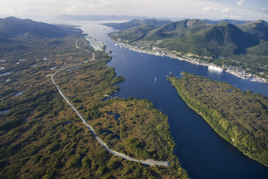
Currently, the Ketchikan Gateway Borough-operated ferry system provides the only scheduled surface transportation to Gravina Island. It services mostly foot traffic, but also carries vehicles across Tongass Narrows from Ketchikan directly to the Ketchikan International Airport terminal on Gravina Island. Regularly scheduled airline service and ferry connections through the Alaska Marine Highway System link Ketchikan to the rest of Alaska and the Lower 48.
The Federal Highway Administration (FHWA) and DOT&PF evaluated a range of alternatives for the Gravina Access Project and issued a Final Environmental Impact Statement (FEIS) in 2004 identifying Alternative F1, a two-bridge crossing at Pennock Island, as the preferred alternative. In its 2004 Record of Decision (ROD) for the project, FHWA selected Alternative F1 and DOT&PF moved forward with final design and construction. In 2007, due to rapidly escalating project costs, then-Governor Sarah Palin directed the DOT&PF to identify the most fiscally responsible alternative rather than proceed with Alternative F1. In 2008, FHWA issued a notice of intent to reexamine alternatives in a Supplemental Environmental Impact Statement (SEIS) and identify and select a different preferred alternative.
Click on the links below to go to desired section |
||||
2017 Signed Record of Decision & final Supplemental Environmental Impact Statement |
||||
Purpose and Need
The purpose of the Gravina Access Project is to improve surface transportation between Revillagigedo Island--home of the Ketchikan Gateway Borough, City of Ketchikan and the City of Saxman-- and Gravina Island, the location of the Ketchikan International Airport and adjoining lands that offer recreational and development potential. Currently, the airport ferry provides the only regular access between the two islands. The airport ferry delivers passengers to the airport terminal and from there they can access lands outside of the airport reserve boundary by traveling along the Gravina Island Highway and Lewis Reef Road. These roads provide access to some private lands and the Ketchikan Gateway Borough’s developable lands north and south of the airport reserve. Bostwick Lake Road, off of Lewis Reef Road, provides access to Alaska Department of Natural Resources lands and the U.S. Forest Service’s timber lands in the interior of Gravina Island.
| The need for improving access is threefold: |
|
Final Supplemental Environmental Impact Statement/Record of Decision (2017)
June 15, 2017 – FHWA and DOT&PF signed the Final SEIS and ROD for the Gravina Access Project. The Final SEIS identifies Alternative G4v as FHWA’s and DOT&PF’s preferred alternative, and FHWA identifies Alternative G4v as the selected alternative in the ROD. The Final SEIS provides additional information about the preferred alternative and explains why it was preferred; documents and responds to all substantive comments on the 2013 Draft SEIS; describes findings, including any required for wetlands, floodplains, and cultural resources; and provides a list of commitments for mitigation measures for the preferred alternative. The Final SEIS also identifies any other findings to be made in compliance with all environmental laws, regulations, Executive Orders, and other related requirements with associated agency consultation.
The ROD, the FSEIS and supporting documentation are viewable here.
Identification of a Preferred Alternative
October 22, 2015 - DOT&PF announced its recommendation for a preferred alternative as Alternative G4v. Alternative G4v is a ferry service alternative that would improve existing ferry facilities for airport travelers and the movement of heavy freight. The alternative includes a passenger waiting facility, a new heavy freight mooring facility and other amenities to improve access for ferry travelers and transporting freight to and from Gravina Island.
Read the press release for the preferred alternative here.
Draft Supplemental Environmental Impact Statement (2013)
August 13, 2013 - The 45-day public comment period closed for the Draft SEIS.
June 21, 2013 - The Gravina Access Project Draft SEIS was released for review and comment.
2009 - The 15 alternatives, which include both bridge and ferry alternatives, underwent a screening process to determine if they were reasonable. Six build alternatives were determined reasonable. DOT&PF and FHWA completed technical studies characterizing the potential social, economic, and environmental impacts of the six build alternatives and the No Action Alternative and incorporated the results into the Draft SEIS. Throughout the process, the DOT&PF and FHWA consulted with federal, state, and local agencies and tribal entities to give all due consideration to a full range of stakeholder interests.
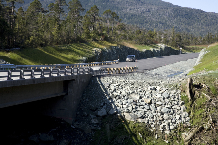
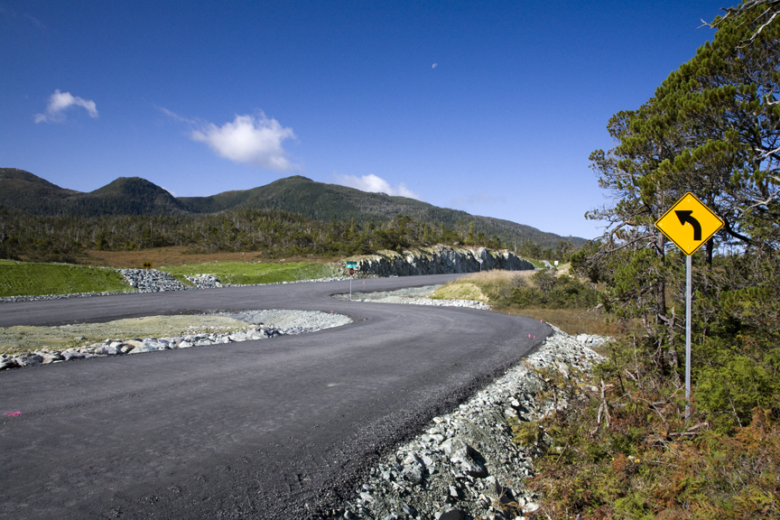
Fall 2008 - DOT&PF completed construction of an element of Alternative F1, the Gravina Island Highway, which is a road segment on Gravina Island intended to connect the Alternative F1 bridge over West Channel to the Airport Access Road. The Gravina Island Highway is now open and provides public access to lands on Gravina Island.
2008 - FHWA and DOT&PF initiated development of an SEIS for the project by reassessing the nine reasonable alternatives evaluated in the 2004 FEIS. Through agency and public scoping, six new alternatives or variations were identified.
September 21, 2007 - Then-Governor Palin announced that the State could not fund the selected bridge alternative identified in the Gravina Access Project ROD (Gravina Access Project Redirected 07-192) and directed DOT&PF to look for the most fiscally responsible alternative for access to the airport and Gravina Island instead of proceeding further with Alternative F1.
Final Environmental Impact Statement (2004)
September 15, 2004 - FHWA issued a ROD identifying Alternative F1 as the Selected Alternative.
July 30, 2004 - the FEIS was distributed to the public and federal and state agencies. The FEIS examined nine build alternatives and the No Action Alternative. The nine build alternatives included six bridge alternatives and three ferry alternatives. Alternative F1 was identified as FHWA’s and DOT&PF’s Preferred Alternative. Alternative F1 would cross Tongass Narrows via Pennock Island with two bridges: a 200-foot bridge over the East Channel and 120-foot bridge over the West Channel.