
Kivalina Evacuation and School Site Access Road Project No.: 0002384/NFHWY00162
Background
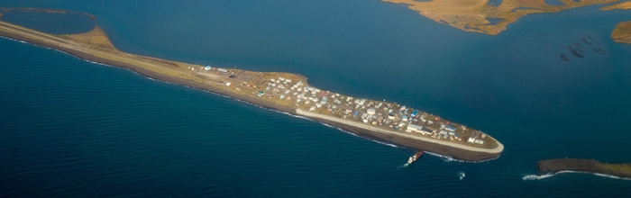
The community of Kivalina has been working for decades with a variety of local, state, and federal agencies to address threats of coastal erosion and flooding. Numerous study, concept, and planning documents exist on potential solutions, which range from: erosion protection around the city; to relocation of the entire community; to a new mainland site. Options involving community relocation have been problematic, as they are neither culturally preferable nor fiscally practical in the foreseeable future. Accordingly, Kivalina has turned to a locally approved approach of facilitating a safe, reliable, and direct means of community evacuation to an acceptable mainland location on K-Hill.
Project Location
The proposed road project origin would be at the City of Kivalina, which lies within the Kotzebue Recording District and is located in Section 21, Township 27 N, Range 26 W, of the Kateel River Meridian. The project terminus at K-Hill is located in Section 19, Township 28N, Range 25W, of the Kateel River Meridian. The feasibility of several potential route alignments were evaluated within a project study area encompassing Kivalina Island, the southern portion of Kivalina Lagoon, and the lower Wulik and Kivalina River drainages in Townships 27N and 28N, Ranges 25W, 26W and 27W of the Kateel River Meridian.
Purpose
The Kivalina Evacuation and School Site Access Road project would provide Kivalina residents a safe and reliable evacuation route in the event of a catastrophic storm or ocean surge, allowing evacuees to temporarily mobilize to safe refuge at an assembly site on K-Hill. This site is also identified by the Northwest Arctic Borough School District, and approved by the community, as a preferred new location for the community school. While school construction is remote and speculative, if constructed within the vicinity of the project terminus, the school could augment the undeveloped evacuation site by serving as a full-service community emergency shelter with all-season support capabilities.
Need
Recent climate data has indicated that arctic sea ice is forming later in the season, increasing fall and winter storm duration and intensity along the Northwest Arctic coast (Simmonds and Keay 2009; Screen et al. 2013). Consequently, residents of Kivalina face significant and increasing risks to life, health, and safety by storm systems predicted to further intensify over time (Brubaker et al. 2010). The need for a concerted effort to mitigate these risks became more evident during an evacuation event in October 2007, when debris-laden storm waves overtopped the barrier island. The event resulted in the need for helicopters to carry evacuees off the island, and illustrated that Kivalina currently has no safe method of evacuation in the event of a catastrophic storm surge. In the face of this increased threat, Kivalina needs a safe and reliable means of evacuation.
Proposed Action
- Establishment of a safe, reliable, all-season Kivalina Lagoon crossing during evacuation mobilization.
- Concepts previously studied for their feasibility include construction of an earthen causeway across the lagoon that variously incorporates hydraulic and boat passage options including bridge(s), culvert(s), or both.
- Construction of an all-season gravel access road between Kivalina Island and the desired K-Hill evacuation site.
- The road would be designed to accommodate both general purpose and emergency evacuation vehicles over a two-way road with shoulders, multiple turnouts, and safe side slopes that include guard rails or other safety features as required.
- Over the last decade, Kivalina and the NAB have evaluated the feasibility of numerous local road routings that could potentially provide for evacuation, school access, or material site development. Evacuation routes considered to date by Kivalina and the NAB have included:
- An alignment referred to as a Northern Route approximately 9.1 miles in length that would originate at the south end of the Kivalina Airport runway, parallel the runway on its east side northward for approximately 1.5 miles, cross the lagoon eastward via a causeway and/or bridge, and follow high ground between the Wulik and Kivalina Rivers to its terminus at K-Hill.
- An alignment considered a Southern Route approximately 6.9 miles in length that would begin at the south end of the Kivalina Airport runway, immediately cross the lagoon eastward via a causeway and/or bridge, and follow lowlands and relic channels of the Wulik River to K-Hill.
- A Combined Route approximately 8.6 miles in length that would follow the Northern route before merging with the Southern route via a one-mile long connecting segment.
- Identification of Material Sources: Although project materials would be specified as contractor furnished and development of material sources would not be included in the Proposed Action, analyses of material locations proximate to potential routes would be conducted to determine their feasibility and evaluate environmental impacts of their development. Four locations in the project study area known to contain potentially viable project materials, and currently being evaluated by Kivalina and the NAB, include:
- K-Hill: K- Hill geology is characterized by exposed limestone and rock rubble at the ground surface. It is anticipated that below the surface, larger frost-fractured rocks and boulders may also exist.
- Wulik River Deposition Zone: The Wulik River Deposition Zone is characterized by visible gravel bars and beaches along the river banks that would contain suitable materials to construct the proposed project.
- Wulik River Relic Channel: The Wulik River Relict Channel is characterized by visible gravel and sand at the ground surface. The fluvial material in these areas was likely deposited when the Wulik River was located north of its present location.
- Kivalina River Deposition Zone: The Kivalina River is also being evaluated for potential material sources due to the areas visible on gravel bars and beaches that appear to contain suitable material.
Reasonable Alternatives
For over a decade, Kivalina and the NAB have evaluated the feasibility of numerous road routes, lagoon crossing options, and material source locations that could provide for evacuation road construction as well as other infrastructure or general material needs. DOT&PF has been working with the community, local and regional government stakeholders, and state and federal agencies to refine evacuation road alternatives to be evaluated under the National Environmental Policy Act (NEPA).
Under the No-Action Alternative, an evacuation road would not be constructed from Kivalina to K-Hill. Residents would continue to be exposed to environmental threats with no safe way to evacuate during storm events with the potential to detrimentally impact the community over time. As a consequence, there would remain severe risk to life, health, and safety of residents during a storm surge event. This does not meet the purpose and need of the project.
Road Route Alternatives: Three preliminary route options (Northern, Southern, and Combined Route A) were independently proposed by Kivalina and the NAB within the Study Area (Community Proposed Alternatives). These community initiated route concepts were refined and a fourth route was developed (Combined Route B) based on feedback received during public and agency scoping efforts in the fall of 2016. Route alternatives were evaluated for feasibility based on purpose and need; engineering considerations; wetland, fish, and wildlife impacts; number and type of water crossing structures; proximity to material sources; and cost. After evaluation (detailed in Section 3 of the attached Final Environmental Assessment (EA)), the Southern Route and Combined Route B were determined feasible and carried forward for further evaluation.
Lagoon Crossing Alternatives: Four lagoon crossing alternatives (Solid Causeway, Solid Causeway with Culverts, Solid Causeway with Culverts and Bridge, and Full Span Bridge) were considered and developed in collaboration with the community of Kivalina, agency stakeholders, and other local and regional stakeholders. After evaluation, only the Lagoon Crossing D (Solid Causeway with Culverts and Bridge) was determined feasible and carried forward for further evaluation (detailed in Section 3 of the Final EA).
Material Source Location Alternatives: Four general areas known to contain potentially viable sources of various project materials were evaluated in past studies. Several material source locations within these areas were evaluated for feasibility based on proximity to potential routes, quantity and quality of material, access constraints, and potential impacts to protected resources (Golder Associates 2013). After evaluation, four potential sources within these areas have been determined feasible and are carried forward for further evaluation (K-Hill, Wulik River Channel Source 1, Wulik Relic Chanel Source 1 and 2).
Selected Alternative
The DOT&PF has selected the Southern Route with Lagoon Crossing D as the preferred alternative based on its ability to best meet the project’s purpose while minimizing environmental impacts and addressing the concerns of the public and agencies. The selected material source alternatives are the K-Hill Site, Wulik River Source 1, Relic Channel Source 1, and Relic Channel Source 2 with the K-Hill site and Relic Channel sources given highest priority, and the Wulik River Source used last, if needed, once the other sites have been exhausted of the needed material. The Southern Route is 7.7 miles long and would begin adjacent to the Kivalina Airport, immediately cross the lagoon with a 3,020-foot long causeway, and follow lowlands and relic channels of the Wulik River to a permanent 5-acre gravel staging pad on K-Hill configured to not preclude later development of a community evacuation site. The selected alternative also includes construction of a second permanent pad near the inland side of the lagoon crossing used for contractor staging.
Project Information
- Project Home
- CMGC Procurement
- CMGC Outreach Meeting
- Study Area & Potential Sites
- Location & Vicinity Map
- Class of Action Determination
- Project Flyover Video Mp4 video, 25MB
Design
- Design Study Report 10MB
Permits
- USACE Section 404 Wetlands Permit 8MB
- Northwest Arctic Borough Title 9 Conditional Use Permit 8MB
- USCG Permit 123MB
- Kivalina Lagoon Bridge
- Kivalina Culverts
- Kivalina Material Wulik
- Kivalina Material Wulik Relic
Final EA
- Environmental Assessment Final 6MB
- Appendix A - D 19MB
- Appendix E - G 31MB
- Appendix H 38MB
- Appendix I - K 16MB
- EA Figures 3MB
For questions or comments, please contact:
Jonathan J. Hutchinson, P.E.
Engineering Manager, ADOT&PF
2301 Peger Rd Fairbanks, AK 99709-5316
![]() (907) 451-5479
(907) 451-5479
![]() jonathan.hutchinson@alaska.gov
jonathan.hutchinson@alaska.gov
To correspond by text telephone
(TDD) (907) 451-2363
The environmental review, consultation, and other actions required by applicable Federal environmental laws for this project are being, or have been, carried out by DOT&PF pursuant to 23 U.S.C. 327 and a Memorandum of Understanding dated April 13, 2023, and executed by FHWA and DOT&PF.
PLEASE NOTE: Adobe Acrobat PDF files require a free viewer available directly from Adobe.