
Seward Airport Improvements Project
Frequently Asked Questions and Comment Themes
The Department of Transportation and Public Facilities (DOT&PF), the Federal Aviation Administration (FAA), and the project team thank you for your comments on the Seward Airport Improvements Project. Below are the questions we’ve heard most frequently and our responses.
Q. What project improvements are planned and how were they selected?
A. The project will shift, lengthen, and raise Runway 16/32 above the 100-year flood level. Some of the taxiways will be raised at the new runway intersection to meet the new runway elevation while others will be deleted in accordance with current Federal Aviation Administration (FAA) guidance. New runway/taxiway lighting will be installed. The river side of the raised runway will receive rip rap armoring to protect it during flood events. The aprons will be repaved, and new navigation aids will be installed. Runway 13/31 and Taxiway A will be closed permanently.
Three alternatives were evaluated during the scoping and environmental process. This project scope corresponds to Alternative 2.2. Alternative 2.2 had the most advantages and least number of disadvantages.
A. Design development was halted at 95% pending final right-of-way acquisitions. Construction is expected in 2026; however, the timing is dependent upon the completion of right-of-way acquisition and permitting.
Q. Why is this project needed?
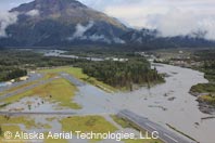
A. Regular flooding of the Resurrection River has increased significantly in occurrence and intensity during the last several years. In response, the Maintenance section of DOT&PF installed a riprap levee. The levee has reduced the number of flood occurrences but has not eliminated them. Hydrologists anticipate that the river will push through the levee and main runway and will flood most, if not all, of the airport. The damage would likely be extensive and may require the airport to shut down in order to complete repairs. In addition to the flooding issue, airport pavement and lighting needs rehabilitation and replacement.
Q. Why not use dredging to move the Resurrection River back to the other side of the river delta?
A. There is no guarantee that the river would stay there. The Resurrection River is a braided river. Braided rivers move back and forth within the river delta, searching for a path of least resistance. Dredging will likely be needed regularly for it to remain effective. The DOT&PF does not have funds for continuing dredging. On-going budget cuts have reduced personnel and resources within its Maintenance section. Previously, it was agreed that the City of Seward and the Kenai Peninsula Borough would continue dredging maintenance. They have not done so, likely due to funding constraints, as well.
Additionally, if the river were forced to the other side of the delta, it is likely that privately-owned properties on that side of the river delta would experience increased flooding. For these reasons, dredging is not a reasonable solution. For more information, consult the paper on dredging, prepared by the Seward Airport Improvements Project’s Hydrologist, available on the project website.
Q. Why not just improve the main runway?
A. This option was evaluated during the scoping process as Alternative 1.1. A flood study showed that this runway would need to be raised several feet to remain above the design flood (100-year) event. Most of this runway is located within the regulatory floodway shown on the Flood Insurance Rate Map (FIRM). Any fill into the floodway that would occur due to raising the runway would result in raising the Base Flood Elevation (BFE) on the FIRM as well as increasing flooding on adjacent properties. Raising the runway to the level needed to protect it would result in additional flooding to approximately 160 acres of private/government properties. While some of these properties are currently vacant, many are not. A revision to this FIRM to change the BFE would require public approval. It’s unlikely the proposed revision would be approved by the public, due to the likely increase in flooding and subsequent increase in flood insurance requirements to the affected property owners.
Finally, the main runway’s location next to the river increases construction and permitting challenges. Permitting agencies expressed concerns about Alternative 1.1. Federal guidance prevents such activities if a feasible alternative exists, such as the currently selected Alternative 2.2. The Environmental Assessment (EA), which is the project’s environmental document, provides a further description of the floodplain impacts anticipated for Alternative 1.1.
This option was evaluated as Alternative 3.0 during the scoping process. While it is possible to build a runway of this length, it would require an additional funding source. Federal funding (FAA) is providing almost 94% of the project costs, so following FAA requirements is mandatory. FAA criteria does not justify a 4,000-foot runway because there are not enough larger aircraft that utilize the airport. Therefore, FAA will not fund this option at this time. The design team collected aircraft traffic information over a period of several years, including several years before the weight restrictions were put into effect for the main runway.
Q. The No-Build option is described in the environmental document. Is this really an option?
A. It is not a feasible option. The airport will continue to suffer damage from flooding. At some point, the main runway will not be usable. If the river breaks through the main runway, the entire airport could be damaged. The Final EA provides additional details regarding why this option is not feasible.
Q. Are the low traffic counts a self-fulfilling prophecy?
A. No. While large air traffic counts do not currently support a longer runway, large aircraft operations could increase in the future. The new runway will have the strength to support larger aircraft. Also, if the City can persuade an air carrier to service Seward again, the City can work with the DOT&PF and FAA to look at a future project to lengthen the runway. As it stands today, the DOT&PF is planning to purchase property for a future 4,000-foot runway to assist with this option. Also, the Airport Layout Plan, currently under development, will show a 4,000-foot runway as an Ultimate Condition. These steps are required as a precursor to receiving FAA funding to construct a 4,000-foot runway in the future.
Q. Can emergency response be used as a justification for a 4,000-foot runway?
A. No. The Design team conferred with FAA about this issue. A runway cannot be constructed for occasional use, even if the use is emergency response.
A. We have listened to this concern expressed by some residents of Seward; however, our involvement is restricted to the airport and state-maintained roads. Both facilities are maintained regularly and to the best degree possible. The DOT&PF has undergone several rounds of budget cuts, significantly affecting the Maintenance section in particular. Clearing the highway after an avalanche is a maintenance priority. Newer equipment makes this a faster process. Helicopters are also available to aid in a potential crisis. In the meantime, Seward does have other modes of transportation, unlike many other small towns/villages in the state. There are numerous villages in the state that depend solely on their airports for food, fuel, clothing, medical evacuations, etc.
Q. How does this project relate to medevac operations?
A. The proposed runway will be capable of supporting the King Air 200, which is the aircraft commonly utilized for medical evacuations. Seward has a local hospital that can stabilize patients until they can be transported by medivac to Anchorage. The local hospital also has a helicopter to meet this need.
A. The City of Seward was interviewed during the scoping process to discuss the probability of future growth and economic development. Interviews showed that the airport does not have regular use by larger aircraft. There were not enough large aircraft landings/take-offs to justify what FAA refers to as a design aircraft. Per FAA guidance, the design aircraft determines the size of the airport facilities eligible for FAA funding.
A. Use of the airport by the Coast Guard was documented. According to FAA, it will not fund public airport improvements to support military aircraft. Therefore, military aircraft use could not be included in the traffic counts used to determine the design aircraft. However, even if military aircraft operations were included, the overall number of large aircraft would still fall significantly short of justifying a longer runway.
Q. Are two runways needed so that pilots have options in varying wind conditions?
A. Orienting the runway to maximize the prevailing wind direction is a key aspect of airport planning. FAA strives to provide facilities that have a minimum of 95% wind coverage, meaning the orientation of the runway is aligned with the prevailing winds 95% of the time. If the winds are not aligned with the runway more than 5% of the time, FAA recommends a second (crosswind) runway. The existing orientation of Runway 16/34 provides 99.7% of wind coverage, exceeding FAA’s minimum requirement. This orientation will be maintained for the new runway. (In contrast, the wind coverage of Runway 13/31 is 96.6%.) During public meetings and private interviews, many pilots supported improving Runway 16/34, over Runway 13/31, for this reason. Pilots can choose to not fly during occasional strong winter winds, much like pilots and small carriers all over the state.
A. This project will not be developing a floatplane access. Alternate float plane access is available at Bear Lake.
A. Yes, the current design calls for fencing along the Airport Access road and south of the airport apron adjacent to the railroad property to the west. The Seward Airport is a federal aid, state-owned airport. The DOT&PF is responsible for ensuring safe operating conditions, which is one of the many grant conditions associated with the acceptance of FAA funding. Failure to adhere to grant assurances jeopardizes future federal aid for improvements and maintenance for this airport. Fencing is a typical component used, at airports nationwide, to ensure safety by preventing airport incursions. Members of the public should not be accessing the airport property, as these instances are considered airport incursions or safety risks. Instead, the public should use public access areas to access the coast.
A. Project construction would require fill to be placed in tidal flats and estuary, an area that provides habitat for salmon and migratory birds (including Arctic Terns and waterfowl). As part of the environmental process, the project team consulted with state and federal resource agencies that have jurisdiction over each natural resource. Results of these consultations as well as impacts to these and other natural resources were evaluated during the Environmental phase of the project and are discussed in the Environmental Assessment.
A. A Hydraulic and Hydrology (H&H) analysis has been completed, which analyzed Resurrection River flooding and considered coastal flooding from Resurrection Bay. Riprap (armor rock) along the relocated Runway 16-34 will be sized according to anticipated storm surges. Current federal guidance precludes incorporating climate change impacts into the evaluation of environmental impacts.
A. Land use impacts and compatibility is discussed in the Environmental Assessment. Birds and airports are incompatible. Birds can cause aircraft crashes and have done so at other locations.
The DOT&PF and the Alaska Railroad Corporation (ARRC) are communicating regarding airport and ARRC port development plans.
Q. What opinions have been received regarding this project to date?
A. There have been three public meetings to date at various milestones during project development. We have heard a broad range of opinions on the project. Some people expressed that an airport with a long (4,000-foot) runway is important to the community. Some other people noted frustration at the airport’s current weight restrictions. Others have commented that Seward is a small community that doesn’t need a big airport. This comment expressed a need for the environment to be preserved over an effort to expand the airport, noting concern over projects that promote more of Seward’s industrial feel at the expense of wildlife/nature/the environment. Other people have commented that they support expanding the small runway over reconstructing the main runway.
A. Preliminary costs/impacts associated with these factors and others were considered during the scoping phase of the project. Refer to the Alternative Analysis available on the project website.
 Seward
Airport Improvements Project (#54857)
Seward
Airport Improvements Project (#54857)Project Information
- Introduction
- Project Purpose
- Photos
- Project Schedule & Team
- Current Events
- Document Library
- Project FAQs
- Contact Us
Regional Links
Use DOT&PF's Alaska Project Exchange tools to learn more about all of DOT&PF's active construction projects statewide!