Dalton Highway Remains Closed From Mile 399-405
Commissioner Luiken Describes the Magnitude of the Event as “Humbling”

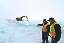
ADOT&PF Commissioner Marc Luiken and Northern Region Director David Miller survey conditions on the Dalton Highway at Mile 401 as equipment works to break through ice to divert water from the road. Commissioner Luiken and Director Miller are standing on the road bed. There are multiple locations along the road where water is running across the road and workers are trying to stop the water.

Workers strategize the best approach to improve conditions on the Dalton Highway. The delineators on the left and right side of the photo are used to mark the edge of the Dalton Highway, the delineators are usually five feet above the road surface. Far in the distance trucks can be seen waiting for the road to open.
(FAIRBANKS, Alaska) – The Dalton Highway remains closed from Mile 399-405 due to overflow from the Sagavanirktok (Sag) River flooding the road. Since March 13, crews from the Alaska Department of Transportation & Public Facilities (ADOT&PF) have worked to keep the Dalton Highway open during an unprecedented overflow event.
"The Dalton Highway is a vital road, and the magnitude of this event is humbling,” said Marc Luiken, ADOT&PF commissioner. “There has been tremendous effort put forward so far, and there will be tremendous effort yet to come. We will get the road open. It is not a question of if, only a question of when.”
ADOT&PF has 16 employees working to open the road in 14 pieces of equipment, including side dumps, excavators, dozers and plows. They are currently working day and night shifts. Yesterday, two contractors joined the effort with 12 additional pieces of equipment, operators and support staff.
Efforts are focused on diverting water from the road near Mile 401. To do this, snow and ice berms are being built and reinforced in an effort to protect the road. Due to the massive ice sheet covering the area, it is difficult to identify the flowing channels of the Sag River. Using satellite imagery, crews are working to identify where water is flowing so equipment can break through ice and work to direct water toward the flowing channels.
The flooding of the Dalton Highway is a result of water from the Sag River. River ice is accumulating in the bottom of the shallow and braided Sag River. This ice is pushing the flowing water to the top, though temperatures in the area remain below freezing. Experts predict that a perfect sequence of snowfall, temperatures and winds lined up to create a massive sheet of ice that expands for miles.
Updates are being posted daily in these locations:
- Dalton website: dot.alaska.gov/nreg/dalton-updates
- Travel conditions: 511.alaska.gov or call 511
- ADOT&PF Facebook: www.facebook.com/AlaskaDOTPF
- ADOT&PF Twitter: @AlaskaDOTPF
The Alaska Department of Transportation and Public Facilities oversees 237 airports, 9 ferries serving 35 communities along 3,500 marine miles, over 5,600 miles of highway and 839 public facilities throughout the state of Alaska. The mission of the department is to “Keep Alaska Moving.”
# # #
| Main Newsroom Page |
