
December 2001

AKDOT using ROWDyS is in the process of streamlining our right of way and utilities project development and permitting procedures; automate workflows; and improve our customer service.
Through conferences and meetings with other state officials we realized that AKDOT was not alone in streamlining procedures and workflows. Since ROWDyS is fast approaching a pilot program testing stage we thought it would be a good idea to see how other state systems handled this challenge. We could learn from the experiences of our colleagues and put these lessons to use in Alaska.
On December 9th through December 14th 2001 Julianne Motis, Engineering Program Project Manager and Rick Kauzlarich, State Right of Way Chief, visited four organizations that were either developing or using some form of data management system. The four organizations were Oregon DOT, City of Los Angeles, Orange County California, and Washington DOT. The purpose of the trip was to see how other agencies were handling management of data and how to provide the public with access to information.
Our hosts in each state were most gracious and helpful; a terrific, dynamic group of people.
The following is a synopsis of the trip:
 ODOT's document management and data system is
a Microsoft Access 97 database "front end" with SQL Server 7
"back end." Two components make up ODOT's system: RAIN (Right
of Way Automated Information Network) and PMI (Property Management Inventory).
ODOT's document management and data system is
a Microsoft Access 97 database "front end" with SQL Server 7
"back end." Two components make up ODOT's system: RAIN (Right
of Way Automated Information Network) and PMI (Property Management Inventory).
ODOT's system can generate multiple federal and state auditing reports.
The system is set up so all units in ROW utilize the program. Agents are assigned specific tasks based on their duties. For instance, Negotiation, Relocation Assistance, Appraisal, etc., a time frame is set up to complete those tasks. Prior to this there is someone that enters into the system the properties they plan to acquire for specific projects. ODOT has five regions that utilize this program as well as their Headquarters staff.
Neither system is available via the web. Internal ODOT users access the systems via their desktop computers. Agents can tap into the system, call up specific documents (offer letters, deeds, memorandums of agreement, etc.), download the documents and populate the documents with project information entered elsewhere.
ODOT's system can be tweaked by ROW staff. In addition, ODOT ROW has a good working relationship with their IT people. A good working relationship means that the public is being served.
RAIN is used for:
· Project Setup Descriptions
· Title Appraisal Review
· Appraisal
· Acquisition of Property
· Closing
· Relocation Review
· Condemnation
Agents tasks in the system consist of the following:
· Appraisal
· Negotiation
· Relocation Study
· Relocation Assistance
· Acquisition
· R/W Clearance Liaison
· Project Management
· Surplus & Sales (actually part of PMI which connects to RAIN).
RAIN can generate various reports (this is only a small listing):
· Grantor Search, File Number or Last Name, or Business Name,
etc.
· Project Search
· Deed Recording
· Completed Projects by Year
· File Status
· Total Appraisals by Fee and Staff
· Relocation Study Appeals
PMI is used for:
· Inventorying Real Property Assets
· Tracking Property Rentals
· Property Disposals
Contact person:
June M. Barber, Data Systems Coordinator,
Right of Way Section, Oregon DOT
1-503-986-3403
june.m.barber@odot.state.or.us
 Los
Angeles established a one-stop web based system for permitting and
accessing other real property use information. This site distributes centralized
Geographic Information Systems, including land base, sewer and storm drain
information. http://eng.lacity.org/permits
Los
Angeles established a one-stop web based system for permitting and
accessing other real property use information. This site distributes centralized
Geographic Information Systems, including land base, sewer and storm drain
information. http://eng.lacity.org/permits
Here is a summary of some of the highlights of the LA system:
- On the web side "Cold Fusion" is used. These are dynamic web pages that communicate with the database to extract information and graphics. In addition, content can be maintained by anyone with access to the Web via a predetermined password.
- Changes to the database are immediately on-line.
- Data base systems including, Microsoft Access, Oracle, SQL servers.
- The system ties in various city data sources.
- An applicant inputs their information and automatic email messages are generated acknowledging receipt of their information.
- Over a two year period LA's permitting system processed 25,000 utility company permit applications. This was done entirely via the web - no visits to the LA permitting counter.
- Offers incentives for using the system - 20% discount off permit fees.
- Public access computers provided at the public counters.
- Online payments are processed through third party interface - Cybersource. http://www.cybersource.com/company/
- Payment reports are processed to LA's accounting department.
Navigate LA http://navigatela.lacity.org/ to display and retrieve land and property information needed to conduct business at the City's Public Counters. It was developed to service not only the current needs to access GIS information, but also to service the future needs as well. As a result of this approach, this website provides for the access data that is currently in development, as well as data that is yet not available on a City-wide basis.
The City of Los Angeles also developed InfoLA. http://gis.lacity.org/infola/
- Access and a visual display of City information and services
- Access to information from other sources including
- parcel maps and associated data,
- demographic data, elected official district maps, and
- information about locations of services available in various neighborhoods.·
- InfoLA was developed using technology known as Geographic Information Systems which provides an intuitive method for viewing information geographically with the aid of maps.
- InfoLA will be expanded over time to provide additional information and access to City services via the Internet.
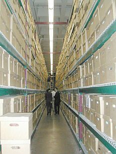 Los
Angeles has a tremendous amount of data. The photo to the left was taken
in a huge storage facility that LA maintains, called the Piper Technical
Center. This view is only a small portion of their Records Management
Division.
Los
Angeles has a tremendous amount of data. The photo to the left was taken
in a huge storage facility that LA maintains, called the Piper Technical
Center. This view is only a small portion of their Records Management
Division.
Another web based service is the LA's "Electronic Vault" http://eng.lacity.org/apps/vault/
The Bureau of Engineering (BOE) has about three million records available. Their "Scan on Demand" plan brings public records online as requests are received for the information. BOE adds an important element of customer service and makes sure that their efforts are directed towards what their information consumers need first.
Search engines allows users to search by Project Title, Project Street, Legal Description, etc. This site links various other BOE data sources such as:
- Alpha Numeric Index
- Survey Bench Mark
- Survey Field Books
- Drainage Maps
- Wye Maps
- Substructures Maps Index
- Topographic Maps Index
- Bridge GIs
Contact person for the LA Permitting System:
Essam Amarragy, PE
Bureau of Engineering Department of Public Works
City of Los Angeles
1-213-847-2501
eamarrag@eng.lacity.org
 The
California portion of the trip was facilitated by Stephen
J. Gilheany, CRM (Certified Records Manager, Association of Records
Managers and Administration). Steve has 20 years of document imaging and
document management experience. For more information see the ArchiveBuilders
web site. http://www.archivebuilders.com
The
California portion of the trip was facilitated by Stephen
J. Gilheany, CRM (Certified Records Manager, Association of Records
Managers and Administration). Steve has 20 years of document imaging and
document management experience. For more information see the ArchiveBuilders
web site. http://www.archivebuilders.com
Contact info for Stephen J Gilheany
1-310-937-7000
stevegilheany@archivebuilders.com
 The
Orange County visit primarily focused
on their Geomatics / Land Information Systems Division.
The
Orange County visit primarily focused
on their Geomatics / Land Information Systems Division.
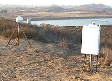
This county division provides surveying and mapping services which support the Public Facilities and Resources Department.
The network consists of:
- · Approximately 2700 stations located on a ½ mile grid throughout the developed areas within the county.
- Majority of these stations have recorded cadastral references and all of them can be used to comply with the Ordinance 3809 "Basis of Bearings requirement."
- Additional stations will be added in the future as areas become further developed.
- Vertical: The two current vertical control datum's are the NAVD 88,
OCS 1995 adjustment and the NGVD 29, OCS 1995 adjustment.
- This network consists of approximately 1700 benchmarks with a ½ mile spacing along the level lines throughout the county.
- Additional benchmarks will be added in the future as areas become
further developed.
Useful URLs provided by Orange County staff:
· http://sopac.ucsd.edu/
Scripps Orbit and Permanent Array Center (SOPAC) provides high precision
geodetic and geophysical measurements using Global Positioning System
(GPS)satellites.
· http://pasadena.wr.usgs.gov/scign/
SCIGN is an array of Global Positioning System (GPs) stations distributed
throughout southern California with emphasis on the greater Los Angeles
metropolitan region.
· http://csrc.ucsd.edu
California Spatial Reference Center (CSRC) website. CSRC has developed
a plan to establish and maintain a state-of-the-art network of GPs control
stations necessary for a reliable spatial reference system in California.
· http://www.ngs.noaa.gov
The National Geodetic Survey (NGS) defines and manages the National Spatial
Reference System (NSRS) - the framework for latitude, longitude, height,
scale, gravity, orientation and shoreline throughout the United States.
Contact person:
Jon Hornecker
Senior Land Surveyor Land Base Maintenance
County of Orange California
1-714-834-3872
horneckerj@pfrd.co.orange.ca.us
 WSDOT
uses their Real Estate Information Service (REIS) for data management.
This system exists on a Microsoft Access server and is accessible to staff
on their desk top computers. At this time there is no web based interface.
WSDOT
uses their Real Estate Information Service (REIS) for data management.
This system exists on a Microsoft Access server and is accessible to staff
on their desk top computers. At this time there is no web based interface.
The system was developed by a consultant and is used by Headquarters staff to track Project related information as well as Property Management data.
Of the systems visited, REIS is the oldest data management system. Staff hopes to update the software and hardware components in the future.
Contact person:
Kaye Thomas
WSDOT HQ
1-360-705-7310
ThomasK@wsdot.wa.gov