

Northwest Alaska Transportation Plan
Community Transportation Analysis
The State of Alaska, Department of Transportation & Public Facilities is pleased to present the Northwest Alaska Transportation Plan (NWATP) Update. The transportation plan was collectively developed by tribal leaders, residents, business owners, agency staff and many others in the area who provided invaluable feedback. The NWATP provides the Department a guide for infrastructure development and decisions over the next 20 years. While the transportation plan covers concepts and recommendations, the Department will continue to review community priorities and collaborate to bring the best possible transportation development to the area. The NWATP originally adopted on February 11, 2004 and was updated in 2022 to provide relevant direction for the area.
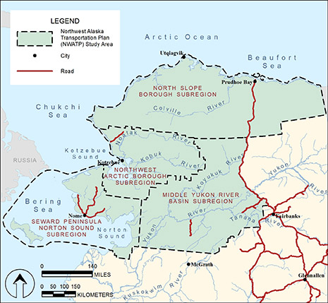
The plan reflects the broad range of concerns, views and perspectives of the people that live and travel in this region which covers the North Slope Borough, Northwest Arctic Borough, Norton Sound/Seward Peninsula, and the Middle Yukon River Basin, an area of approximately 217,865 square miles. The plan considers marine, river, aviation, trail and highway transportation, as well as other economic, demographic, and technological forces at work in this and adjoining areas of Alaska.
The plan addresses passenger and freight inter-community movements by land, air and water modes. In the accompanying Resource Transportation Analysis, the plan will address the transportation needs of mineral, coal, and oil/gas developments. The Northwest Alaska Transportation Plan constitutes an element of the Statewide Transportation Plan.
If you have questions regarding the content of this page, please contact Eric Taylor at 907-465-8958 or eric.taylor@alaska.gov
Site Updated July 2022